https://www.worldhistorymaps.info/wp-content/uploads/2021/03/map-486ad.jpg
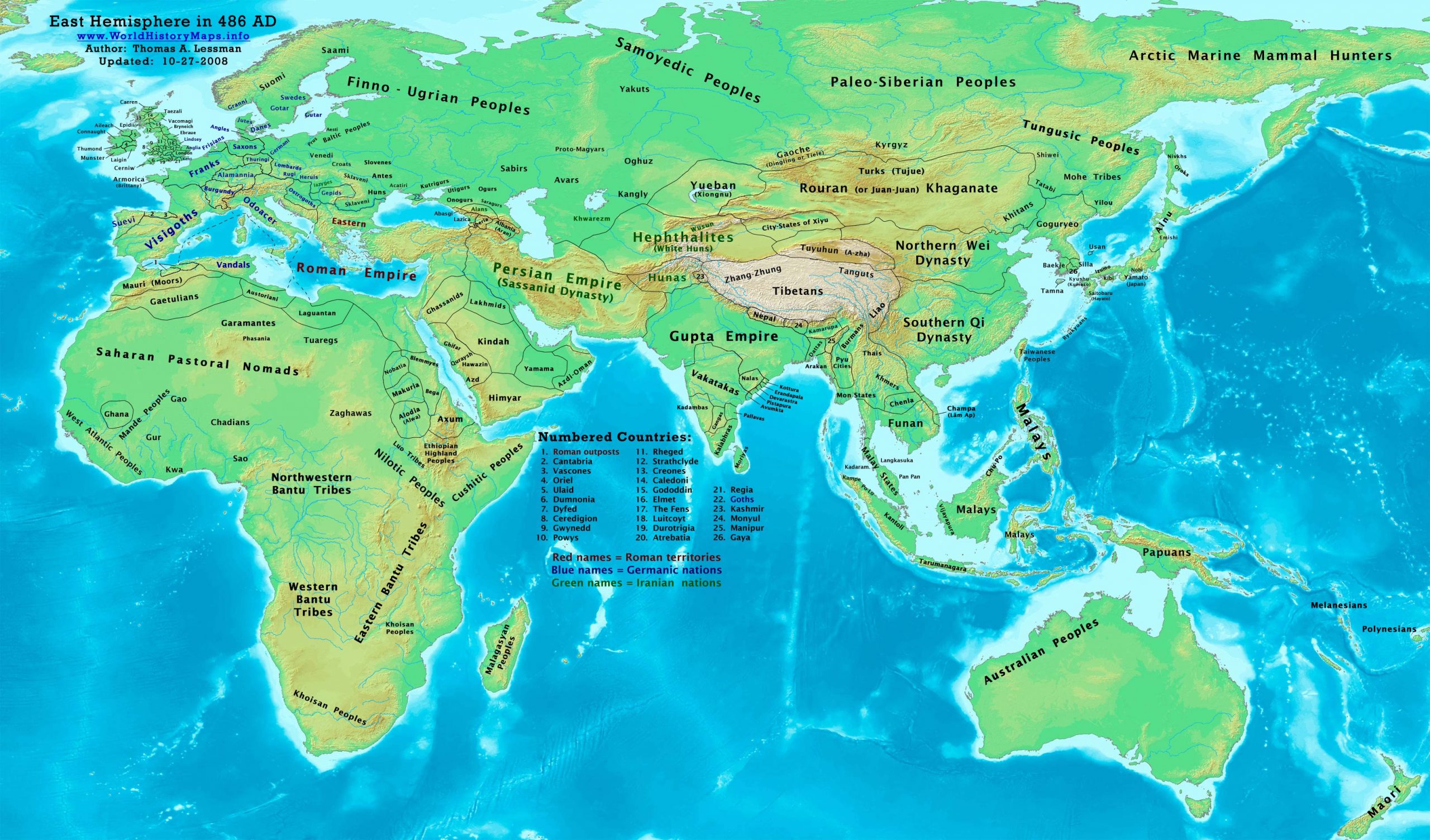
Primary Sources for East-Hem_486ad.jpg:
- The DK Atlas of World History, 2000 edition. (See specific references below)
- User:Javierfv1212. Map of the “The_world_in_500_CE.PNG”. Available on Wikipedia.
I – African information:
* African Tribal locations are derived from:
- The DK Atlas of World History. Map of “Development of Complex Societies in Africa”. Pg 160.
(Bantus, Berbers, Chadians, Cushites, Garamantes, Gur, Khoisans, Mandes, Nilotics, West Atlantic Peoples, etc.)
II – Asian information:
* Greater India (Including modern Bangladesh, India, and Pakistan):
* Korean & Manchurian information:
- Park Hyeon. Map of “History_of_Korea_300_BC.png”. Available on Wikipedia.
III – European information:
* British Isles information is from:
- David Nash Ford. Early British Kingdoms. Map of “Britain in 475 AD”.
* European borders are primarily derived from:
- Euratlas. Periodical Historical Atlas of Europe. Map of “Europe in 500 AD”.
IV – Australia, Siberia, & Other Fringe Areas
Note: Fringe information is derived from comparisons of these sources:
- The DK Atlas of World History, 2000 edition. Map of “The World in 500 CE”. Pgs 50-51.
- User:Javierfv1212. Map of the “The_world_in_500_CE.PNG”. Available on Wikipedia.
Note: Much of the information in this map was cross-checked with Bruce Gordon’s Regnal Chronologies.
Europe
Battle of Soissons: Frankish forces under King Clovis I defeat the Gallo-Roman kingdom of Soissons (Gaul). Roman rule under Syagrius ends. The land between the Somme and the Loire becomes a part of the Frankish Empire. Syagrius flees to the Visigoths (under king Alaric II), but Clovis threatens war and he is handed over for execution.
Clovis I establishes his new residence at Soissons. He appoints Ragnachar, Frankish petty king (regulus), as his deputy ruler.
Source: Wikipedia

